  |
|


| Siniloan | Maculot | Manabo | Manalmon | Daguldul | ||||
| Notes courtesy of Omar | |

Well well well, what can I say, my body is still aching with pain as I was writing this notes, but it's worthy. Mt. Batulao, is located at Nasugbu, Batangas is one of the exciting mountain experience that we ever done because of its beautiful view of Batangas Province, the Taal Lake, and the other mountains besides it and its peaks are wonderful because its jagged saw-tooth appearance covered with cogon grasses. Another thing (as yamet said), the mountain is productive with fruits (such as blueberry, bayabas (guava), avocado, kasuy (cashew) etc.). The name Batulao came from a scene "bato sa ilaw" (rock in a light) which happens where the sun rises right between the two peaks. | |
|
Batulao is classified as Level 2,
Minor Climb. From Manila, ride a bus going Nasugbu via Tagaytay, you
can take Crow Station at Pasay Rotonda or BLTB. The jump-off point
is at the Evercrest Golf Course, from there ride a tricycle going to
the market/plantation and start trek on the long road. We start
climbing late afternoon and arrived at the campsite about 4 pm and
also, a pre-assault was been done just after dinner. Summit assault
is done the following day. Wear protective clothing cause the trails
are exposed to heat and cogon grass is taller than
you. This is probably one of our hardest climb basically because of lack of preparation but if you will take it on the other side, it is really an exciting and definitely fun climb (with this people around me). The most hardest part is our descend, where lack of water is a big problem. Have you ever felt earthquake in a mountain? we have. After the descend, we go to Nasugbu and wash ourselves with the waves of the beach. Pictures |
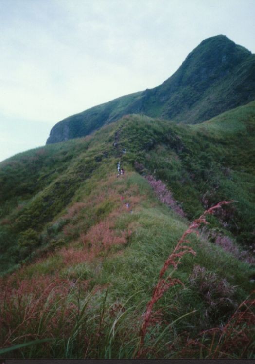 Majestic beauty |
 | |
 Giant marble rock |
Daraitan, is a barrio which is a part
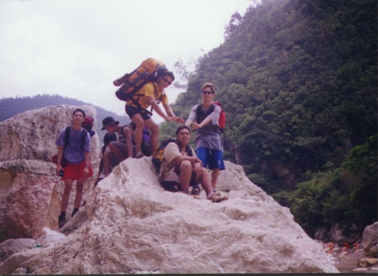
of Sierra Madre located at Tanay, Rizal. To get here, ride a jeep from EDSA Crossing going to Tanay. Then from Tanay, you can do some last marketing at the Tanay Public Market. From Tanay, ride a jeep bound to Daraitan. Here you will experience an exciting ride, with the roads so tough, full of curves, and really a thrilling one especially when your on the top load. At the jump-off, the start of the trek is by crossing the river which is about hips (if it's me) high then a walk through rocky ground. The trail is established since is the same trail used by the locals. You will be passing by large rocks (marbles), river system, high mountain peaks, and river again. |
|
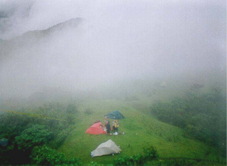
The campsite is so large and can
accommodate many tents. Beware of horse shit which is allover the
campsite. Water sources are available. The place offers lots of activities such as rock climbing, river crossing, swimming, caving, trekking, climbing, and kayaking. The place is not fully explored even by mountaineers so its a great time to explore it by yourself and conquer your fears. Another thrilling ride as we left when we are at the top load of the jeep with the rains are pouring unexpectedly and we got a flat tire, you will be in doubt if you can still go back to your home. Pictures | |
 | |
Mt. Romelo, which well known as
Famy(but should be Siniloan) by mountaineers because it is located
at Siniloan, Laguna, it is a part of Sierra Madre Mountain
Range. Siniloan is said to be most accessible trekking
destination during summer since it consists of several waterfalls
namely Buruwisan, Sampaloc, Batya-Batya, and Lanzones. Buriwisan is
the most visited camp by mountaineers and its where you can develop
your rappelling skills since there is a water below that will break
your fall. We decided to trek at Sampaloc Falls, which is less
visited camp than other falls. To go to Siniloan, assemble at 7-Eleven Store at EDSA-Crossing, in-front of EDSA Shangri-la Plaza. Take a regular jeepney trip to Tanay, RIzal. From Tanay, take another jeepney trip to Siniloan, Laguna. You will be approached by tricycle drivers at Siniloan public market that will take you to jump-off point along the Siniloan to Infanta highway. Register at Aling Esther's Store, from there you can start the trek which will take you about 2 hours up to the campsite. | |
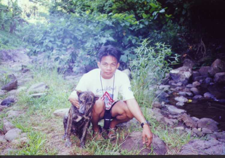 Blackie with His Master (Xaru!) |
Aling Esther owned a dog which is
Blackie which lead us to the Sampaloc Falls and stayed with
us overnight and up to our descent back to trailhead, the dog is
with us but we didn't know his name, some call him bruno, brusko,
rambo, pumpoy, bulldog, tiger, and many names that came out until we
trek back to trailhead and got his name. There are many rest stops
and store along the trail where you can buy food and drinks in case
you run out of supply. Siniloan classified as Level 1, Minor Climb. Trails are well-established but guides would be needed. Potable water is abundant and it is a good place to practice your swimming lessons. Pictures |
 | |
From South Superhighway (riding at a
bus trip Lemery), passing through the tows of Calamba, Sto. Tomas,
Tanauan, Malvar and Lipa, we arrive to the town of
Cuenca. Which is located at the foot of Maculot. It is 99 km away from Manila. It
is founded on August 11, 1875, and became an independent parish in
1879 with a patron saint San Isidro Labrador. Makulot (sometimes called Macolod), is located at the northeast boundary with Laguna and said to have a name after the kinky-haired people who lived in the mountain. The mountain is located at the southeastern shore of Taal Lake and has a rounded, densely forested main summit and an extended mountain on its west which is a rocky 700 m high (which is called Rockies). | |
|
Before we start our climb, we were
advised to register (at 5 pesos per person) at the Barangay 7 Hall.
The initial trail was fair, passing through a gravel path and then
entering a forest. The trail become steeper as we enter the forest,
rest stops become more frequent. The last quarter of the hike was
through even narrower path through tall cogon grass (talahib). There
is a 7-11 and Uniwide Family store at the top (I mean a convenient
store where it offers cigarettes, bread, candies, buko juice, soft
drinks and even hard drinks). We went to the Rockies (now I know where they got such a name), where the view of the Taal Lake and the Volcano Island is spectacular. The other side of the mountain are Stations of the Cross. Peak days are from Fridays to Sundays when up to 200 campers converge. |
 A minute rest |
|
Makulot s classified as Level 1,
where a fit person can climb it in an hour. Trails are
well-established and guides would be a help. Heat and dehydration
plus a steep and slippery trail are to be expected. Bring lots of
water cause water source is 100 m away from the campsite. Wear
lights clothes and a good hiking shoes. If you intend to go
overnight, bring tents, sleeping bags, jackets and pajamas or
jogging pants (coz its very cold at night and winds are sometime
strong), first-aid kits and flashlights or lamps. Bonfires are not
allowed so bring portable stoves and utensils when you intend to
cook. Pictures | |
 | |
The guys assembled at Buendia Jam
Terminal at about 6 am, (6 nga ba?) and ride a bus going Batangas,
while I’m waiting at Fiesta Mall, Lipa (because I came from Batangas
City). They arrived at bus terminal of Lipa at about 9 am (tama
ba?). So nagtricycle pa ko pabalik ng bus terminal. Then another
ride of tricycle to the jeepney stop bound to Sulok. At about past
10 am, we arrived at jump-off point Sulok, Brgy. Sta. Cruz. We
consult the locals before we start the ascent cause none of us knows
the trail, it’s really an exploration climb. | |
|
We arrived at the river system,
prepare launch (pack launch daw?) and start eating around 12 noon.
We decided to take a rest first at the river system because the sun
is up and the weather is really hot. We resume ascent at about 2:30
pm and reach the summit in 2 hours approximately. There are lots of
trails in this mountain so it’s really bit confusing one. At the
summit, there are lots of cows eating the carabao grasses. I
think it took me 15 minutes to pass this cows cause they really look
angry to me. The summit is really amazing, you’ve got 360 degrees
view of Batangas and nearby places like Laguna, Taal Lake, Quezon
and other mountains such as Makiling, Maculot, Banahaw, Cristobal,
and other peaks of Malipunyo | |
|
(which is Bagwis and Malipunyo itself). At top of
it, there is a big cross that makes this mountain a holy one. The
place is cold especially at night because it’s open and hot on
daytime. No potable water supply so bring enough h20 for your
consumption. We start descent the next day at 9 am and reach the
river system in a half hour (pretty quick one). Take a bath, prepare
lunch, and take lunch. We arrived at jump-off point at 12:30 pm and
refreshed with buko and halo-halo. The locals are very helpful and
kind to us, the others take a bath at one of the local’s house. We
depart at 1 pm going to Lipa bus terminal, take a break at McDonalds
and all gone home and have a nice exploration climb
achievement. Pictures |
 Our campsite from peak |
 | |
Mt. Manalmon is said to be a
part of Biak na Bato National Park. It is very uncommon to have a
mountain in Bulacan since it is famous for flat lands and
rice fields. As suggested by Yamet (and guided by Gerald), climbing
this mountain gave us a new experience since it is our first climb
in the north and points of interest is great. Assembled at Baliwag
Bus terminal in Caloocan, andun n si Nardo, nauna sa lahat. Wala sa
plano ang pagsama nya, kasi ayaw payag ang syota nya at may pasok
siya sa IT. He and Troy talk about that he will go to work instead
of Troy - so that Troy can join us. Biglang
nag-backout si Xaru, sinumpong uli ng sakit ng tyan. Nasa
kanya pa naman ang ibang equipment at food na binili namin kagabi.
Too bad, we'll miss him for this climb. When Troy and others arrived,
nagulat sya kc andun si Nardo at Rhannie so walang tech ngaun sa IT
except for Boyet. | |
|
Then Manong (I don’t know the
name) offered us to ride in his Revo instead of a bus and he will
take us directly to jump-off. Ayun, nakatipid kami (70 per person
instead of 80 sa bus and 60 sa tricycle). On our way, nag-txt na si
Boyet kay Nardo, asan na daw sya, nag-alibi na lang ma may LBM sya
(totoo naman). At the jump-off, there are other group of
mountaineers already in there. We started to ascend when
somebody told us to stop and we need to register and hire a guide.
Guide fee cost 500 box ( natawaran pa ng 400, wala din ang natipid
sa transportation). Then we arrived to the river just right for
lunch. Take a rest, swim, and took pictures. |
 Part of 360 deg. view around Manalmon Peak |
|
Then at about 3 pm, we continue to
ascend. The trails are steep, muddy, and slippery. We arrived at the
campsite in less than an hour and started pitching our tent. The
rain caught us that noon (buti n lang tapos na kaming mag-pitch,
wala tuloy clearing for sunset). The lights are off at around 10 pm
(sarap sanang matulog kaso may nag-iingay pa). Next day, I wake
up past five to catch the sunrise but its still a foggy morning. We
descended around 9 am and passed by the cave ( I think its named Madilim n
Kweba). The guys test their strength by passing across the river
through the wire hanging on it (grabe, nakakapanginig). Then we took
our lunch (spaghetti kasi birthday ko daw) at the small falls just
near the jump off. We left there by 2 pm with Manong’s Revo as our
service back to Manila (Nag-iisip na nang dahilan si Nardo
kasi may meeting sila kinabukasan). Pictures | |
 | |
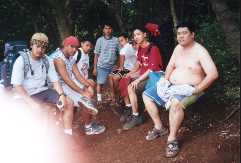
Third day after the climb, buti na lang wala nakong sakit na nararamdaman, di tulad nung Lunes, para kong nag-major climb. Climbing Daguldul is not that easy, although it is leveled minor and moderate, we find it a hard one. Meeting time at 6 AM, on the usual meeting place (7-11 Buendia cor. Taft Ave.) I arrived there past 6, with Yamet, Xaru, Jenny, and Mel already waiting for me. Ronald is still not around, sabi na nga ba, drawing na naman. Ang nawawala ay sina Donna at Romy, we wait until 7 but there’s no sign of them. We depart Buendia past 7 AM bound to Lipa Bus stop (through JAM Transit, 82.50 pesos). Traffic at Brgy. Turbina, Calamba so we arrive Lipa at almost 10 AM. A tricycle ride takes us to the jeep terminal bound to San Juan (5 pesos). From Lipa to San Juan is an hour drive (22 pesos) and another hour from San Juan to Brgy. Hugom (20 pesos) takes us to the jump-off point. We done marketing back at San Juan Public Market. | |
|
At the jump-off, a registration fee of 25 pesos and guide fee of 350 pesos (for a group of 15). We join another group of climbers (Ian’s group), totaling us to 31. Trek starts alongside of the beach; about 30 minutes walk through sand before we reach the first rest stop, where halo-halo awaits the mountaineers. From that stop, ascent through the forested mountain starts, trail is like a zigzag road going to Baguio, it looks like an easy trail but the left and right turn makes it a difficult one. We start the trek 1 PM, and we reach the campsite (Niyugan) almost 6 PM. Nahirapan talaga ako sa trek na ito, ako nga ang nahuhuli sa grupo, kahit yung mga batikan sa akyat tulad ni Yamet at Xaru, wala din (lalu na ung mga first timer na sina Mel at Vanj). There’s really something in this mountain that make it hard. The campsite is big, and water source is available (water pipe is located at the campsite itself). After pitching the tent, we start cooking our dinner; we better start early because were down only to one stove (kasalanan ni Romy to e). Chopsuey, tocino, and spaghetti (birthday ko daw kasi) ang panghapunan. It’s about 9 where we start our dinner, mga gutom na gutom | ang lahat kaya ang sarap kumain. After the dinner, its social time courtesy of Troik’s emperañing. Lakas tama. Kitang-kita sa picture ung mga tinamaan. Socials end past 11, I’m bit dizzy and tired so I prepare myself to sleep, so as others, Lights out. Wake up call 5 AM, where Yamet already preparing breakfast (di daw sya nakatulog ng maayos dahil sa emperador, lakas kasi uminom). I hurriedly went to the other campsite at the peak (called Gulugod Baboy or Campsite 1) to catch the glimpse of the sunrise. Full moon is still visible at the other side of the mountain, near Mt. Malipunyo. Sunrise past 5, but it’s still covered by the other side of the mountain, so I wait few more minutes for it to come up with Mel, Jenny, and Vanj also go there to join me. | 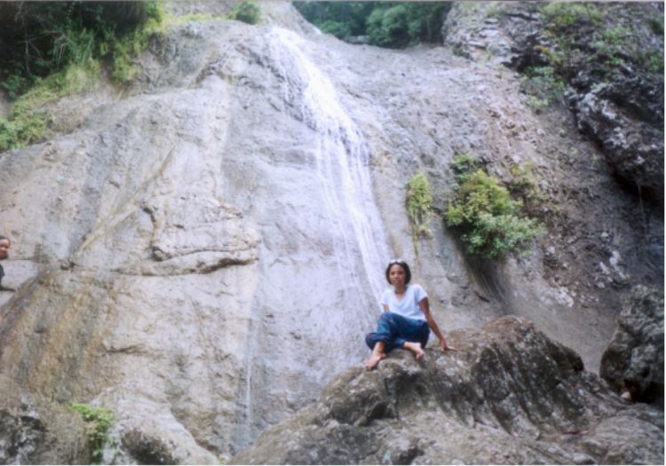 Naambon falls |
Back at the campsite, breakfast already prepared, hotdog, tea, at mga tira-tirang pagkain kagabi. After the dinner, its social time courtesy of Troik’s emperañing. Lakas tama. Kitang-kita sa picture ung mga tinamaan. Socials end past 11, I’m bit dizzy and tired so I prepare myself to sleep, so as others, Lights out. Wake up call 5 AM, where Yamet already preparing breakfast (di daw sya nakatulog ng maayos dahil sa emperador, lakas kasi uminom). I hurriedly went to the other campsite at the peak (called Gulugod Baboy or Campsite 1) to catch the glimpse of the sunrise. Full moon is still visible at the other side of the mountain, near Mt. Malipunyo. A 360 degrees view of Batangas (including mountains like Maculot, Makiling, and Banahaw) is still visible although it is a foggy morning. Sunrise past 5, but it’s still covered by the other side of the mountain, so I wait few more minutes for it to come up with Mel, Jenny, and Vanj also go there to join me. Back at the campsite, breakfast already prepared, hotdog, tea, at mga tira-tirang pagkain kagabi. Break camp at 7, we plan to descent at 8 (nagmamadali kasi si Yamet, may shower party pa kasi siyang pupuntahan) so advice Ian about our plan that we will descent early than their group. Start descent, the best part of the climb. Ratratan na ‘to, wala kang gagawin kundi itapak lang pababa ang iyong mga paa na parang may tumutulak na sayo. Before 9, we reach the first rest stop just near the house of Mang Zardo where we got a taste of fresh buko juice serve by the local kids (10 pesos each), that washes mg hang-over (even Yamet too). Continue descent again till we reach the trail going to Naambon Falls, we leave our packs on the trailhead and descent for about 5 minutes to reach the falls. Naambon is not the usual, it is a tall rock face where small amount of water flowing on its surface, it doesn’t have a catch basin. Picture taking time, para may remembering. Past 10 when we leave the falls and reach jump-off at 11. Take a bath at one of the public CR and eat bulanglang for lunch. Waiting there is the jeep that brought us here, we aboard and leave Brgy. Hugom by 12 noon. By 2 PM, we say goodbye to each other at the Lipa bus stop. Vanj and me bound to Batangas, Jenny in Lipa itself, and the four others going to Manila. We reach Batangas before 3, plenty of time to unpack things and go to church to thank God for this wonderful climb. Wherever you are, I will always be… Pictures
|
| Top | Batulao | Daraitan | Siniloan | Maculot | Manabo | |||||
 |
 |
 |
 |
 |
 |
 |